Perusahaan ini terdaftar sebagai Free Member. Hindari melakukan pembayaran sebelum bertemu penjual atau melihat barang secara langsung. COD (Cash On Delivery) atau bertemu langsung dengan penjual merupakan metode transaksi aman yang kami sarankan.
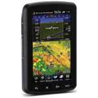
Negara Asal Taiwan GPS Garmin Aera 795 The Garmin aera 795 incorporates the popular features of the Garmin 695 but the 795 also has new capabilities such as a touchscreen user interface, pilot-selectable screen orientation and 3D Vision. The Garmin aera 795 also takes the pilot one step closer to a paperless cockpit with a digital document viewer and scratch pad. The aera 795 has a high-resolution and sunlight readable 7-inch capacitive touchscreen display that can be viewed in portrait or landscape mode. The physical design has been optimised to fit on the yoke and is sized perfectly as a knee-mounted device. There are four touch keys on the bezel of the unit representing " Back " , " Menu " , " Direct-To " and " Nearest " for quick navigation to frequently used functions, and because the aera 795 is customisable, the user can also pick favorite features or pages to anchor as icons along the bottom of the screen for even faster access. The display has large, finger-touchable icons with intuitive pictures and labels to indicate their function such as: map, terrain, 3D Vision, WPT info, FPL list, active FPL, numbers, doc viewer, charts and tools. Pilots can choose any of these functions by simply touching the appropriate icon. The touchscreen interface also allows the pilot to quickly pan across the map and pinch/ pull zoom. The aera 795 features 3D Vision from Garmin, a unique 3D view of database-generated terrain. 3D Vision uses GPS position and the terrain-alerting database to recreate and display a behind-the-aircraft perspective view of the topographic landscape. The resulting virtual reality display offers pilots a 3D depiction of land and water features including terrain, obstacles, runways and airport signposts all shown in relative proximity to the aircraft. With a flick of a finger the 3D view can be rotated around the aircraft to easily view the surrounding terrain. Using forward-looking terrain avoidance capability, the aera 795 predicts in advance where potential hazards may exist and colourises the landscape showing amber or red overlays on those areas. Any towers or obstacles that may encroach upon the flight path are color-highlighted and clearly displayed with height-appropriate symbology. For pilots who prefer Jeppesen charts and diagrams, Garmin also offers a ChartView enablement option. Garmin ChartView utilises Jeppesen' s extensive library to provide global charting capabilities. Other features include a built-in digital document viewer that enables the pilot to load and view PDF documents, JPEG photos, and many other electronically formatted materials including checklists and detailed performance/ procedural data from the aircraft flight manual. There is also a convenient scratch pad for writing down clearances or other important notes.