Perusahaan ini terdaftar sebagai Free Member. Hindari melakukan pembayaran sebelum bertemu penjual atau melihat barang secara langsung. COD (Cash On Delivery) atau bertemu langsung dengan penjual merupakan metode transaksi aman yang kami sarankan.
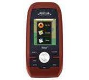
Jual GPS Magellan eXplorist 110 Merk: MAGELLAN Kode Produk: GPS Magellan eXplorist 110 Ketersediaan: Stok ada Harga: Rp. Negosiasi GPS Magellan eXplorist 110 The Magellan eXplorist 110 GPS receiver comes with essential navigation features and is ready to use right out of the box. A vibrant, transflective colour screen allows for the best readability in direct sunlight. To zero in on the exact location of a geocache, favourite fishing spot, or the next lookout, the SiRFstarIII GPS chipset provides accuracy of 3-5 meters. To keep your outdoor adventure going all day long, the device is powered by two AA batteries for 18 hours of constant usage. The eXplorist 110 is rugged, waterproof, and submersible ( IPX-7) . All of this is packed into a small and attractive handheld case that can be hung around your neck with the optional Magellan lanyard or attached to your pack with the built-in carabineer hook. The eXplorist 110 is pre-loaded with the World Edition map, which includes a complete road network in the Australia, United States, Canada and Western Europe and major roads throughout the rest of the world. This unique map also includes water features, urban and rural land use, and city centres. With the 110 you can overlay a series of different transparent compass styles on top of the pre-loaded World Map that shows roads, water features, parks, and city centres. The dashboard screen has a mini-compass for quick reference and customisable navigation data fields, such as latitude, longitude, heading, bearing, distance to end, trip odometer, and much more. View your active track, which is a series of digital breadcrumbs that records all your movements. Mark your starting point ( car, campsite, parking lot) with a waypoint and easily navigate back at the end of the day. Reference your track summary to keep track of your distance travelled, elevation gained or lost, complete travel time, moving time and stopped time, and average time to find. Easily reset your track summary statistics to track the details of your next geocaching adventure. No matter where you enjoy the outdoors, camping, hiking, fishing, walking, the eXplorist 110 will get you there and back again safely. Easy to Navigate Menus and Rich Graphics Simple to use main menus and sub menus and vibrant graphics make this device easy to use Brilliant, sunlight readable colour screen A vibrant 2.2" colour transflective screen provides the best readability in direct sunlight Rugged and waterproof to IPX-7 standards Focus on the adventure, not protecting the device High-sensitivity SiRFstarIII GPS with 3-5 meter accuracy 3-5 meter GPS accuracy provides a superior and accurate navigation experience Pre-loaded World Edition Map Referencing a complete road network in Australia and overseas to help with orientation. See parks, rivers, lakes, major city points, and other types of land use areas. 18 Hours of battery life using 2 AA batteries Go strong for an entire day ( or more) . And easily recharge with a spare pair. Suspend Mode The goal is to conserve battery life by putting the device into an advanced power-saving mode. Suspend Mode will turn off everything expect for GPS tracking. Wake up the device with a single click. Paperless Geocaching Download and view more than 20 unique characteristics of each cache and view, search, filter on the device. 500 MB of user memory available Loads of space to store geocaches, waypoints, and tracks. Record Tracks and See Keep a log of all the steps you took throughout the day. Reference your track to find your way back or to keep a digital journal of all your outdoor adventures. Track Summary Start your journey with one-click and keep tabs on useful statistics such as distance travelled, average speed, elevation gained, descent, and average time to find. NMEA Message Output ( USB Only) For hardcore outdoor GPS enthusiasts who want to connect their device to laptop running VantagePoint software and see your position on the computer screen. Multiple Coordinates and Map Datums Navigate around the world and do it accurately. See your geographic location in UTM coordinates . Various coordinate displays and Map Datums available depending on your preference and requirements. Device Dimensions ( English) 2.2" x 4.4" x 1.4" Dimensions ( Metric) 56mm x 111mm x 36mm Weight ( English) 5.20z Weight ( Metric) 147g Battery Type 2xAA Battery Life 18 Hours Waterproof IPX-7 Available User Storage 500 MB/ Not Applicable CPU 233MHz Temperature Range ( F) 14F to 140F Temperature Range ( C) -10C to 60C Suspend Mode Yes Internal Memory 2 GB Screen Display Resolution, WxH QVGA, 240 x 320 Screen Size 2.2" Display Type Color, Transflective GPS & Sensors GPS Accuracy Up to 3-5 meters High-Sensitivity GPS SiRFstarIII™ Antenna Type Multidirectional Patch WAAS/ EGNOS/ MSAS Yes Mapping & Navigation Preloaded Maps World Edition Points of Interest Yes Vertical Profile Yes Area Calculation Yes Hunt & Fish Calendar Yes Sun & Moon Information Yes Coordinates Systems & Datums Yes Audible Proximity Alarms Yes User Generated Content Accepts GPX Files Yes Waypoints 500 Routes 25 Geocaches 500 Legs Per Route 25 Paperless Geocaching Yes Tracks 10 Points Per Track 5000 User Data Online Sharing Yes Interface & Communications Communication Protocol USB Mass Storage USB Port Yes NMEA Output Yes PC Compatible Yes